Know when the weather turns on the mountain.
GRAT is a decision-support tool for climbers and hikers. It combines forecast models, official warning services, station observations and your iPhone's barometer into a single risk level — for the point you are standing on and the altitude you are at.
The level never travels alone: it always comes with why it is what it is, and which model or service said so.
How you use it
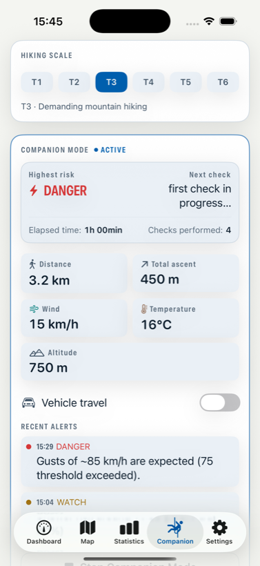
- Pick the route's difficulty (T1–T6) The thresholds move with it. A gust that is merely unpleasant on a T2 path is a reason to turn around on a T5 ridge, so the same wind is judged differently.
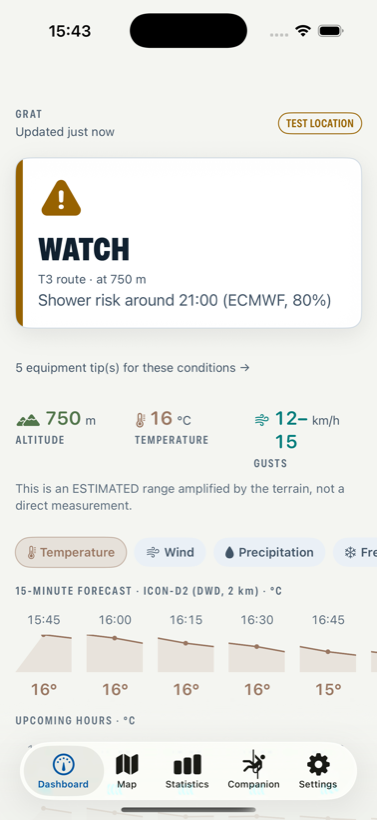
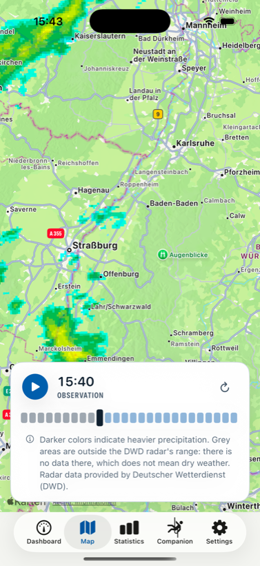
- Check the dashboard before you leave One verdict for your location and altitude, with the reason and the source. Tap through for the hourly and 15-minute detail, the radar, or the equipment hints for those conditions.
- Start Companion Mode at the trailhead From then on the app re-checks conditions every 15–20 minutes while you walk, and notifies you if the risk rises. It also tracks distance and ascent — and pauses them when it detects you are travelling by car.
- Read the alert, not just the colour Every notification carries the threshold it crossed and the model it came from, so you can judge it yourself instead of trusting a colour.
- Close the loop afterwards When you stop the session you get a log: when each check happened, where gaps were, which alerts were sent. You can mark each alert as appropriate or unnecessary — that is what calibrates the thresholds.
What it shows
- Shower and thunderstorm risk — roughly when, and from which model
- Wind gusts — with thresholds that follow the route grade and terrain amplification
- Cold and getting wet — altitude-corrected temperature and wind chill
- Official warnings — DWD in Germany, MeteoAlarm in the Alps, NWS in the US; never machine-translated, always with their source
- Precipitation radar — DWD, RainViewer and NOAA depending on where you are
- Pressure trend from the phone's barometer — the one reading that still works with no signal at all
On your wrist, and in Health
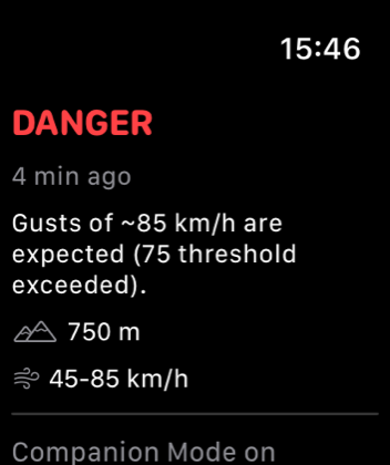
The Apple Watch app shows the last verdict, its reason, and — always — how old that reading is. It computes nothing itself: a second risk engine would mean two screens that can disagree, and in a safety app that is the worst possible bug.
Optionally, a finished session is written to Apple Health as a Hiking workout with its route. GRAT only writes; it never reads your health data.
What it deliberately does not do
GRAT doesn't tell you what to do. Setting off, going on, turning back, taking shelter — those decisions are yours alone.
It sends no alerts while the app is closed, and it says so instead of implying otherwise. In some regions there is no radar, lightning or official-warning data — and no data does not mean no risk. "SAFE" never means there is no danger.
Missing data is neither hidden nor invented. What can't be measured reliably is shown as "—", never as "0", and stale values are shown with their age.
Under the hood
GRAT is built and maintained by one person. A few decisions are worth naming.
Sources, and what each is for
| Layer | Source |
|---|---|
| High-resolution model | ICON-D2 (DWD, 2 km) in its coverage area; HRRR (NOAA, 3 km) over the US |
| Broad models | ICON Seamless and ECMWF IFS, via Open-Meteo |
| Official warnings | DWD (Germany), MeteoAlarm (Alps and most of Europe), NWS (US) |
| Station observations | Bright Sky/DWD in Germany, METAR elsewhere |
| Radar | DWD, RainViewer, NOAA nowCOAST |
| On the device | Barometric pressure trend, motion activity, GPS |
Where models disagree inside the ICON-D2 area, GRAT takes the worst of them. That decision came from a measurement, not a preference: over 30 days of archived forecasts, D2's own convective rule caught 12% of German storm hours while ECMWF caught 52%. More false alarms, fewer missed storms.
No server, no account
There is no backend. No sign-up, no analytics, no tracking, no ad SDK. Your session history, feedback and routes live on your iPhone only. Location goes to the weather services rounded to three decimal places (~110 m), never with an identifier attached.
Honesty as an engineering rule
Three rules are enforced in code and in tests, not just in the design document: an empty series is never drawn; an unreliable measurement renders as "—"; and risk colours belong to the risk level alone — they never leak into measurement data.
29 acceptance tests
Each one compiles the real source files, not a copy. Several replay archived fixtures from real storms.
Three first-class languages
German, English and Turkish. No user-facing string lives in code; official warnings are never machine-translated.
Dynamic Type throughout
Measured contrast, 44 pt touch targets, and layouts that survive the largest text size.
Works offline
Cached data is shown with its age; the barometer keeps working with no signal.
Privacy
No servers of our own, no accounts, no sign-up, no analytics or advertising. Read the full privacy policy →
Status
GRAT is in early access on TestFlight. It won't reach the App Store before it has been tried in real conditions on the mountain.
Questions, bug reports and feedback: support@gratweather.com